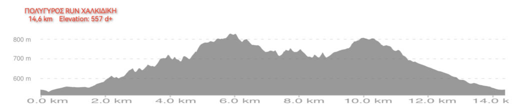
DETAILED ROUTE DESCRIPTION – 14,4 KM RACE
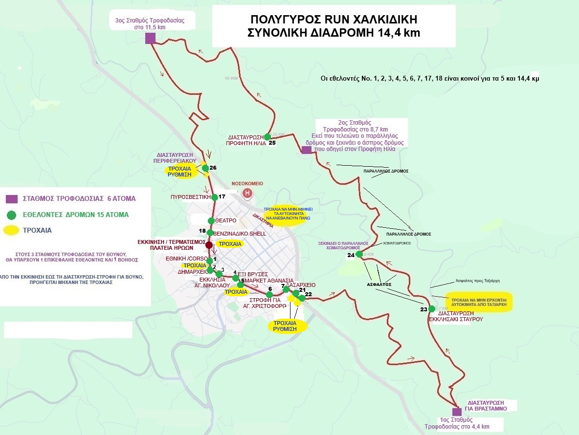
The race starts at Heroes’ Square (Plateia Iroon) and heads downhill along Polytechniou Street towards the Town Hall. We then continue along the pedestrian street until we reach Six Fountains (Exi Vryses), where we turn right and then left, heading uphill along Akanthou Street towards the Forestry Office area. At the junction near the Forestry Office, we turn right and continue along the Polygyros–Ierissos Provincial Road. Approximately 200 metres after the Forestry Office, we turn left and head uphill towards the mountain, following the road towards KEKYKAMEA. After covering a total distance of 2,2 km on asphalt, we turn diagonally left onto a dirt road (the old road to Vrasta). Continuing uphill, at approximately 4,4 km from the start, we reach the 1st Aid Station. We continue uphill for another 1,3 km until we reach the asphalt road at the location known as “Stavros Chapel”, approximately 5,7 km from the starting point. From there, we continue downhill for 1,1 km on asphalt, along the road coming from Taxiarchis. We then turn diagonally right onto a smooth forest dirt road, which we follow for approximately 2 km until reaching the 2nd Aid Station, located approximately 8,75 km from the start. We continue uphill until we reach the highest point of the course, at approximately the 10 km mark. From this point onwards, the route follows a continuous downhill section all the way to the finish. At approximately 11,5 km, we reach the 3rd Aid Station. We continue downhill and, at the 13 km mark, reach the asphalt road (the old Polygyros–Palaiokastro road). From there, we continue on a gentle downhill section, enter the town via Polytechniou Street, and head towards the finish line at Heroes’ Square (Plateia Iroon).
DETAILED ROUTE DESCRIPTION - 5 KM RACE
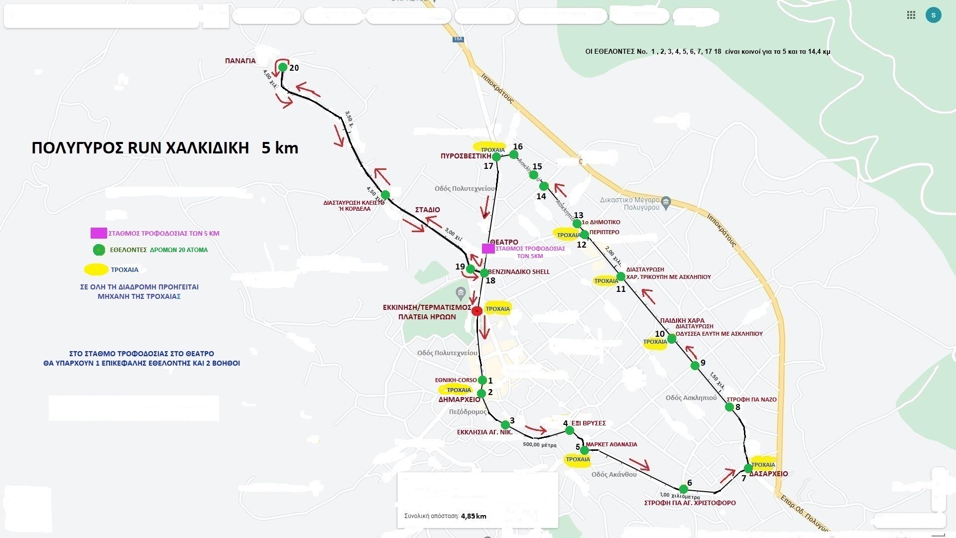
The race starts at Heroes’ Square (Plateia Iroon) and heads downhill along Polytechniou Street towards the Town Hall. We then continue along the pedestrian street until we reach Six Fountains (Exi Vryses), where we turn right and then left, heading uphill along Akanthou Street towards the Forestry Office area. At the junction near the Forestry Office, we turn left onto Asklipiou Street and continue along it until we reach the 1st Primary School of Polygyros. We continue straight along Asklipiou Street until we reach the Fire Station, where we turn left and head downhill along Polytechniou Street. We pass in front of the Municipal Theatre of Polygyros, where the Aid Station is located. We continue straight ahead and, upon reaching the Shell petrol station, turn right and head towards the Municipal Stadium of Polygyros. We then continue towards the Chapel of Panagia, where we make a U-turn and head back towards the Municipal Stadium. After passing the stadium, we turn left towards the Shell petrol station, then turn right onto Polytechniou Street and continue towards the finish line at Heroes’ Square (Plateia Iroon).
5 Km Route Map
14,4 Km Route Map
Wikiloc : https://el.wikiloc.com/oreibasia-diadromes/polygyros-run-halkidiki-14-4-km-284372713
Route Elevation Gain